This Month's Highlight of California Collections
Courtesy of
Fair Oaks Historical Society

MAP OF FAIR OAKS
PRINTED IN 1900
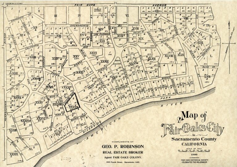
This map of Fair Oaks, California, printed in 1900, was reproduced by the Fair Oaks Historical Society as part of its Millennium Project in January 2000.
George Robinson, the real estate broker listed on this map, came to Sacramento from Boston specifically to sell property in the Fair Oaks area. While he had an office on “J” Street in Sacramento, he also had a Fair Oaks office.
This map was probably prepared earlier by Stephen Kieffer, who not only had done the first survey of Fair Oaks in 1895, but who also was an officer of the Fair Oaks Development Company, with whom Robinson did business.
A good portion of this map was in the eyes of the developers. Many named streets either didn't exist yet or were simply driveways to some of the early homes.
The bridge markings shown indicate a potential bridge, agreed to by the County Board of Supervisors, which had yet to be built.
Howard and Wilson Avenues were named after the owners of the promotional firm, the Howard-Wilson Publishing Company, which conceived, laid out and sold the first Fair Oaks properties.
Howard Avenue was named for Civil War General Charles Henry Howard, who it is thought named the town because of its resemblance to Fair Oaks, Virginia where his brother, General Oliver Otis Howard, lost his right arm in battle.
C.H. Howard's business partner and author James W. Wilson named Wilson Avenue for himself.
For the full narrative regarding this map see the 1900 map page on the Fair Oaks Historical Society’s website.
The Society’s website provides access to scanned copies of maps, photographs, booklets, and manuscripts from its collection. Please visit https://fairoakshistory.org for more information.
Thank you to this month's contributor!
Courtesy of
the Fair Oaks Historical Society
https://fairoakshistory.org